Warning: Creating default object from empty value in /home/sites/30b/a/a8be13db6d/public_html/wp-content/plugins/zanmb/reduxframework/ReduxCore/inc/class.redux_filesystem.php on line 29

Warning: Cannot modify header information - headers already sent by (output started at /home/sites/30b/a/a8be13db6d/public_html/wp-content/plugins/zanmb/reduxframework/ReduxCore/inc/class.redux_filesystem.php:29) in /usr/share/php/wp-stack-cache.php on line 1971

Warning: Cannot modify header information - headers already sent by (output started at /home/sites/30b/a/a8be13db6d/public_html/wp-content/plugins/zanmb/reduxframework/ReduxCore/inc/class.redux_filesystem.php:29) in /usr/share/php/wp-stack-cache.php on line 1972

Warning: Cannot modify header information - headers already sent by (output started at /home/sites/30b/a/a8be13db6d/public_html/wp-content/plugins/zanmb/reduxframework/ReduxCore/inc/class.redux_filesystem.php:29) in /usr/share/php/wp-stack-cache.php on line 1973

Warning: Cannot modify header information - headers already sent by (output started at /home/sites/30b/a/a8be13db6d/public_html/wp-content/plugins/zanmb/reduxframework/ReduxCore/inc/class.redux_filesystem.php:29) in /usr/share/php/wp-stack-cache.php on line 1971

Warning: Cannot modify header information - headers already sent by (output started at /home/sites/30b/a/a8be13db6d/public_html/wp-content/plugins/zanmb/reduxframework/ReduxCore/inc/class.redux_filesystem.php:29) in /usr/share/php/wp-stack-cache.php on line 1972

Warning: Cannot modify header information - headers already sent by (output started at /home/sites/30b/a/a8be13db6d/public_html/wp-content/plugins/zanmb/reduxframework/ReduxCore/inc/class.redux_filesystem.php:29) in /usr/share/php/wp-stack-cache.php on line 1973

Warning: Cannot modify header information - headers already sent by (output started at /home/sites/30b/a/a8be13db6d/public_html/wp-content/plugins/zanmb/reduxframework/ReduxCore/inc/class.redux_filesystem.php:29) in /home/sites/30b/a/a8be13db6d/public_html/wp-includes/feed-rss2.php on line 8
Fife – Easymalc's Wanderings https://www.easymalc.co.uk I’d be unstoppable if only I could get started Sun, 24 May 2026 13:59:20 +0000 en-GB hourly 1 https://wordpress.org/?v=7.0.6 https://www.easymalc.co.uk/wp-content/uploads/2019/09/cropped-easy-malc-logo-32x32.jpg Fife – Easymalc's Wanderings https://www.easymalc.co.uk 32 32 140253175 Scotland’s Secret Bunker https://www.easymalc.co.uk/scotlands-secret-bunker/ https://www.easymalc.co.uk/scotlands-secret-bunker/#comments Sun, 24 May 2026 13:59:20 +0000 https://www.easymalc.co.uk/?p=11297 Originally posted 2020-11-19 05:28:14.

The post Scotland’s Secret Bunker appeared first on Easymalc's Wanderings.

]]>

Scotland's Secret Bunker

It may not be the first thing visitors to Fife think of doing, but you should make every effort to come and see this extraordinary underground nerve centre where plans were put in place to keep Scotland functioning, should there be a nuclear attack.

Just a 10-minute drive from Crail, a quiet lane leads through the Fife countryside and a barbed-wire fence to what looks just like an ordinary farmhouse, but was in fact, the guardhouse that would have protected the command centre of the Scottish government had it become necessary. Today, it’s the visitor centre welcoming people into the bunker.

Entrance to the Bunker
The Guardhouse

So how did this come about? Well, initially after the end of WWII the British government decided to build a string of early warning radar stations along the east coast of Britain, with those at most risk being built underground. Fife has a Royal Navy dockyard at Rosyth and at the time also had an RAF base at Leuchars, and so consequently it was decided to build this underground complex at Troywood. It was such a well-kept secret that apparently even the locals didn’t know it was here.

The Bunker above ground

A 150 metre tunnel leads from the Guardhouse down into the bunker, which is on two levels, the lowest being 30 metres (almost 100ft) underground. As the threat of a nuclear attack increased then the bunker needed to adapt, and in the early 1970s it was refurbished to accommodate its new role, which it did until 1993.

The Tunnel leading down to the Bunker

Some 300 personnel were employed here and there are 42 rooms that can be accessed (some still can’t be for security reasons). Obviously, I can’t describe them all here but they include everything that would help the country to survive after a nuclear attack.

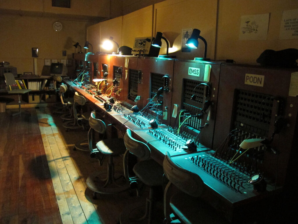
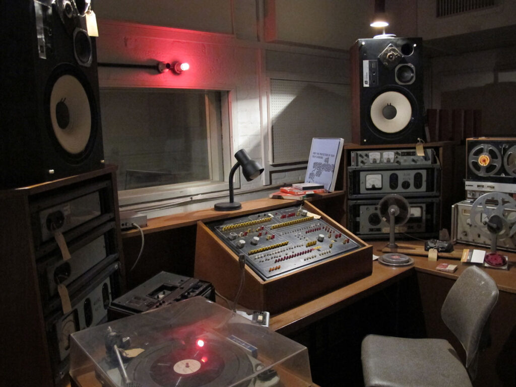
The pictures below show a Dormitory, Telephone Exchange, Emergency Services Control Room and a BBC Studio.

There was, of course, all the facilities needed to keep the bunker going such as the Mess Hall, which is now a visitors’ café

The Mess Hall, now the Cafe

The room where the Radar operators monitored any potential threat would undoubtedly have been one of the most important of all, and it sends a shudder down my spine to think that a 4-minute warning was all we had (have) in order to deal with a nuclear attack.

The Radar System Room

The Minister of State for Scotland was responsible for taking the appropriate action if the worst-case scenario happened, and he had his own office/bedroom next to the Nuclear Command Control Centre.

The Cold War thankfully finished some time ago now, and on 1st April 1994 the Bunker was opened up to the public. It may not have been on your radar beforehand, but Scotland’s Secret Bunker really shouldn’t be a secret anymore. Don’t miss it.

The Nuclear Command Control Centre

Originally posted 2020-11-19 05:28:14.

The post Scotland’s Secret Bunker appeared first on Easymalc's Wanderings.

]]>
https://www.easymalc.co.uk/scotlands-secret-bunker/feed/ 21 11297
The Isle of May https://www.easymalc.co.uk/the-isle-of-may/ https://www.easymalc.co.uk/the-isle-of-may/#comments Wed, 15 Apr 2026 09:43:59 +0000 https://www.easymalc.co.uk/?p=7522 Originally posted 2019-06-03 17:10:16.

The post The Isle of May appeared first on Easymalc's Wanderings.

]]>

The Isle of May

Located in the mouth of the Firth of Forth, about 5 miles and a 45-minute boat ride from Anstruther, is the uninhabited Isle of May. I say uninhabited, but that’s not strictly true because it’s home to a fantastic collection of seabirds.

If you think that this is yet another lovely peaceful Scottish island, you’d be wrong because the first thing that will hit you when you arrive on this 1½ mile long island is the deafening noise made by around 200,000 birds.

Admittedly, it was breeding season when we came, and apart from bringing some ear plugs, I would also recommend wearing a hat, preferably a white one.

Terns
Terns

Most of the cacophony of noise seemed to be coming out of the beaks of the 4 different species of tern that breed here, who also had a nasty habit of dive bombing anybody who strayed a bit too close to their nest – and even those that didn’t.

I’m not sure why they felt threatened really, because the island is a National Nature Reserve, owned and managed by Scottish Natural Heritage who obviously make sure that the well being of the birds come first. When you arrive on the island a warden greets passengers off of the May Princess, and then gives a short talk about the island and guidelines on where you can, and can’t go. It’s mostly just common sense to be honest.

03-Map-of-the-Island

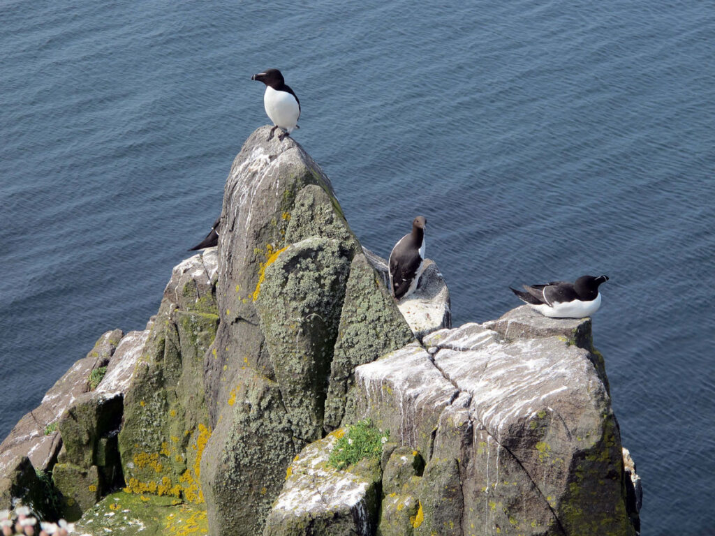
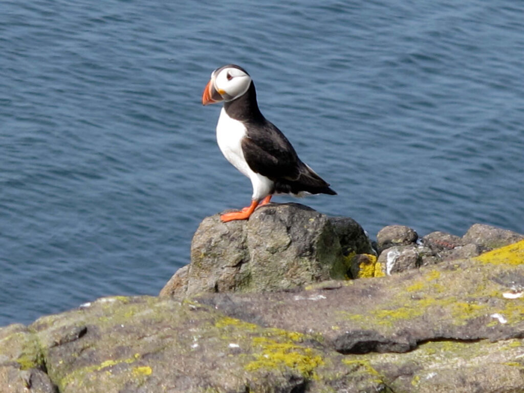
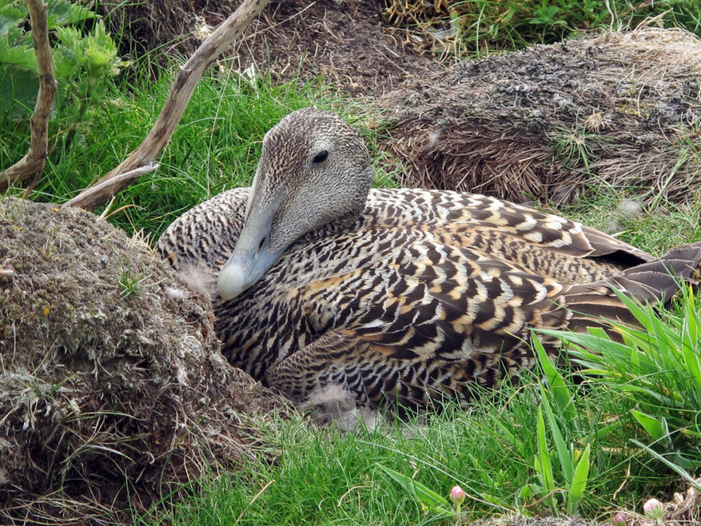
Before I go any further, I have to admit that although I love watching birds I’m no expert: Even so, it was easy enough to spot some of my favourites; there were plenty of Guillemots, Razorbills, Puffins, Kittiwakes and Gannets (but not as many as there are on Bass Rock): There’s also a new addition to my list of favourites – the Eider Duck. I couldn’t help but fall for a female who was sat on her nest and not in the least bit bothered my presence.

The carousel shows some Guillemots, a Puffin and the female Eider Duck.

Guillemots and Razorbills
A Pair of Kittiwakes

The birds are the undisputed stars of the show, but there are other things to see and do in the 3 hours or so that you’re given to explore the island.

A short distance from the arrival and departure point at Kirkhaven are the ruins of a priory built by Henry I in 1125 in memory of St. Adrian, an Irish missionary who was murdered here by Vikings in 875, but a more substantial relic from the past is The Beacon, Scotland’s first ever lighthouse.

It’s not difficult to see why The Beacon was built: After many shipwrecks and loss of life, Alexander Cunningham constructed the square tower near the centre of the island in 1636 with a coal-burning beacon on top.

You would think, wouldn’t you? that everybody would be grateful for this aid to saving lives, but not so. The problem was of course, that the cargo from shipwrecks found its way into the hands of locals who could put it all to a much better use, or at least that’s how they saw it.

No doubt The Beacon did help to save many lives, but perversely, there were some that it also took.

In 1791 a storm blew out the Beacon for two days, and a short time afterwards, the keeper, his wife and five of his six children were found dead: It seems that the embers from the Beacon caused poisonous Sulphur dioxide fumes to seep into their bedroom while they were asleep.

The Beacon

This Beacon was superseded in 1816 by the nearby unmistakable Main Light designed by Robert Stevenson (uncle of the author Robert Louis Stevenson). It’s still in use today but operated remotely. It’s not the only lighthouse on the island either, but the Low Light (built in 1844) is now used as a bird observatory.

Lighthouses are meant to be seen, and foghorns are meant to be heard, and there are two monsters on the island which thankfully didn’t need to be used during our visit, but I think we would have needed those earplugs if they had.

The Main Light
The Main Light
The South Horn
The South Horn
The Low Light
The Low Light

By the time you’ve walked around the island, observed the birdlife, and taken in some of the island’s features, it’ll be time to leave Kirkhaven.

Kirkhaven
Kirkhaven

Our journey from Anstruther to May had brought us along the eastern side of the island, but the return sailing was to take us around the other side, where not only could we see the cliffs and birdlife up close, but also some of the resident grey seals. Outside of the breeding season the numbers of seals that can be seen are around the hundred mark, but come the Autumn the population increases into the thousands when around 4,000 seals haul themselves ashore, mate, and give birth to around 2,000 pups.

Guillemots on the cliff edges
Seals at South Ness
Seals at South Ness

The May Princess runs from the beginning of April to the end of September and so it’s possible to see some of the first pups at the end of the season. The breeding season for the seabirds is between April and July.

The trip lasts between 4½ and 5 hours and currently costs £28 for a full fare-paying adult and concessions apply (June 2019).

If you’re ever lucky enough to find yourself in the East Neuk of Fife and the weather’s looking good, take my advice and jump on board the May Princess and head out to the fantastic Isle of May. Even if you forget your earplugs and hat, you won’t forget the Isle of May.

https://www.isleofmayferry.com/index.php

The Western Coastline

Originally posted 2019-06-03 17:10:16.

The post The Isle of May appeared first on Easymalc's Wanderings.

]]>
https://www.easymalc.co.uk/the-isle-of-may/feed/ 21 7522
The East Neuk Fishing Villages https://www.easymalc.co.uk/the-east-neuk-fishing-villages/ https://www.easymalc.co.uk/the-east-neuk-fishing-villages/#comments Wed, 01 Apr 2026 13:04:03 +0000 https://www.easymalc.co.uk/?p=6719 Originally posted 2019-03-06 22:14:22.

The post The East Neuk Fishing Villages appeared first on Easymalc's Wanderings.

]]>

The East Neuk Fishing Villages

‘Neuk’ is a Scottish word for nook or corner, and if you take a look at the map opposite, you’ll see that the East Neuk of Fife is the bit that juts out into the North Sea at the end of the Firth of Forth.

Along this coastline are a string of attractive fishing villages, the most interesting being St Monans, Pittenweem, Anstruther (including Cellardyke) and Crail.

If you’ve travelled to Fife over the Forth Bridge, then the first of these villages is St. Monans, about an hour’s drive away. There are several theories as to who St. Monan was, but the church that is dedicated to him is often described as Scotland’s nearest church to the sea, which is only around 20 metres away. It’s been here since the 14th century so whether it’s been that close since it was built, I wouldn’t like to say.

St Monans Church

Walking downhill to the harbour there’s one of those simple little things that appear to mean nothing much but somehow manages to lift the spirits in an ever more disenchanting world.

The idea of the ‘Wellie Garden’ was conceived by Win Brown, a local teacher who decided to put her grandchildren’s wellie boots to good use. Her students joined in, and before she knew it the slipway had amassed around 200 pairs of boots filled with an assortment of plants that not only brightened up the slipway but many people’s faces as well.

The Welly Boot Garden
05

Of all the harbours along this coastline, St Monans is one of the smallest, but in my opinion, also one of the most picturesque. Not only was fishing big business here, so was boat building. Sadly, not only have the majority of fishing boats disappeared, so too have the boatyards.

St Monans Harbour
St Monans Harbour

Another industry that has gone the same way here is salt production. Just a short wander along the coast path out of the village towards Pittenweem is a windmill that stands testament to the once thriving, but short-lived source of income for the village. The nearby hollows in the ground show where the sea water was heated in the salt pans and powered by the windmill.

St Monans Windmill
St Monans Windmill
The Salt Pans
The Salt Pans

About half an hour’s stroll from the salt pans will bring you into the slightly larger village of Pittenweem.

The footpath brings you into the village by way of the West Harbour with its small boats and fishermen’s cottages. These cottages give way to larger houses that once belonged to ship owners and sea captains who once plied their trade with the Low Countries. This trade saw the introduction of the type of building style more associated with the Netherlands and Belgium with red pantiled roofs and crow-stepped gables, and some of the best examples are at The Gyles at the eastern end of the main harbour.

West Shore, Pittenweem
Gyles
Gyles

The main harbour is the busiest along this stretch of coastline, and although it has a daily fish market, the catch is still relatively small compared to the north-eastern fishing ports of Peterhead and Fraserburgh.

The Main Harbour, Pittenweem

‘Pittenweem’ apparently means ’Place of the Cave’ and presumably refers to St. Fillan’s Cave which is situated in Cove Wynd near the harbour.

Apparently, this cave, although several metres above sea level now, would have been formed by sea erosion and has been used as a storage place and shelter for who knows how many years.

It’s association with St. Fillan goes back to the 8th century when the Irish missionary set up home here. Supposedly blessed with special healing powers, he was also deemed to have had a “luminous left arm by which he saw to read and write”; I have to say though, that it never ceases to amaze me how these saints possess all these different miraculous powers and all come from Ireland.

St Fillan's Cave
St Fillan's Cave
Inside St Fillan's Cave

You won’t need any miracles to help you get to get to the next village along the coast as it’s less than a couple of miles away.

Anstruther is the largest of the East Neuk fishing villages and, sitting as it does around half way along this coast, is probably the most convenient place to stay. It also has the most amenities, which of course, also makes it the busiest. That said, it’s still only a community of around three and a half thousand people, so don’t come here expecting a great metropolis.

A look at the local Ordnance Survey map reveals that there’s an Anstruther Wester and an Anstruther Easter, and the Dreel Burn used to be the dividing line between the two; the burn still runs into the sea but the town has long been unified and is now just called Anstruther.

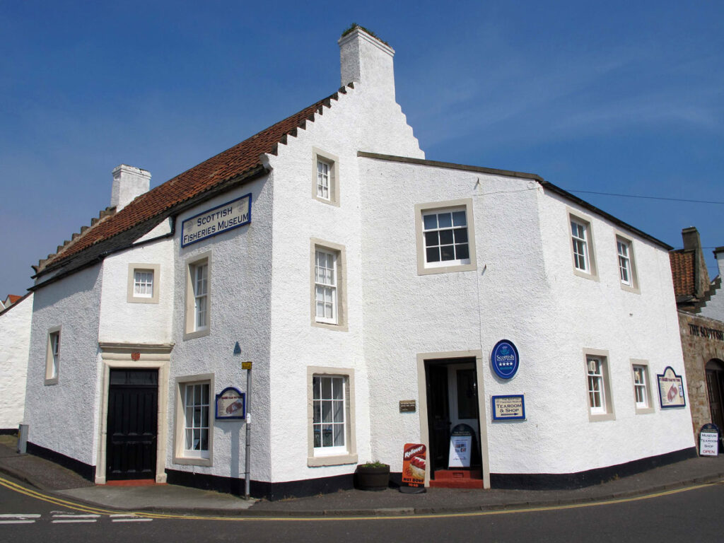
As with all the other villages along this coastline, fishing has traditionally been the main industry, but with the decline of the shoals of herring it also meant the decline of Anstruther. Although the village is larger than Pittenweem its harbour is not as busy with fishing boats, but as tourism has become more important it seems as good a place as any to have a museum devoted to Scottish fishing.

Anstruther
Anstruther

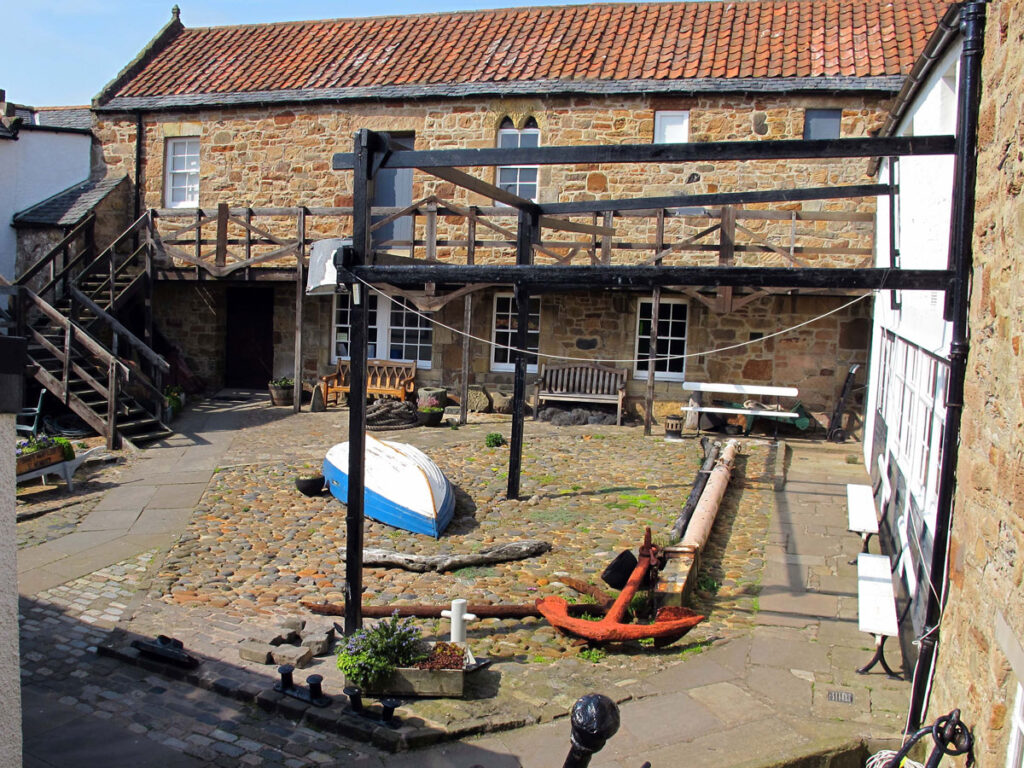
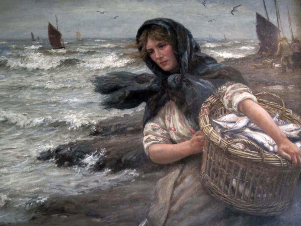
The Scottish Fisheries Museum is an excellent national museum located on the harbourside in buildings that date back to the 16th century. These buildings surround a cobbled courtyard that was involved in fishing as long ago as the 14th century, and in amongst all the fishing paraphernalia are some Heritage Boats and a collection of evocative paintings by Pittenweem artist John McGhie.

The quayside opposite the museum is the departure point for the boat to the Isle of May (which I’ll be describing separately), but if eating fish is more your thing than catching them, then after visiting the museum make sure that you allow enough time to visit the nearby Anstruther Fish Bar.

I say allow enough time because, with awards as long as your arm, this place is a bigger attraction than the museum, and you’ll need to be prepared to queue up whether it’s for the restaurant or the Take -Away.

In my opinion, the best place to eat your Fish Supper (as they call it up here), is on the harbourside where the benches just seem to have become an outdoor extension to this obligatory stop along the coast road through the village.

The Anstruther Fish Bar

If you drive out through the village and keep to the coast rather than the main road, you’ll come to another little harbour at Cellardyke, which although these days is regarded as a part of Anstruther, has its own separate identity. If you miss the signs to Cellardyke, do yourself a favour and turn back because although it’s not the easiest of places to find, you’ll be glad you did.
In the past it was a busier fishing harbour than its larger neighbour, and though it may be difficult to imagine now, apparently over 200 fishing boats used this harbour until a storm in 1898 damaged it enough to force the boats down into the better and newer one at Anstruther.

Cellardyke
Cellardyke

So how did the name Cellardyke originate? Well, the story goes that the dykes (walls) that were used to hang the fishing nets over to dry, glistened in the sun with the scales of the silver darlings (herring) and so were called “Sil’erdykes”.
There’s no fishing nets left out to dry on the harbour these days but washing is. It’s this sort of thing that sets the village apart from its neighbours. The boats maybe gone but there still seems to be a sense of community here amongst the narrow streets of terraced houses.

021

The final fishing harbour on our East Neuk tour is the small village of Crail, which can be reached by joining the A917 from Cellardyke. Parking is encouraged in the village rather than the harbour which will give you the opportunity to check out the small Museum and Heritage Centre situated next to the Dutch styled Tolbooth. It won’t set your pulse racing but it also doubles up as a friendly and welcoming Visitor Centre.

Crail Town Hall and Museum

It’s the harbour that most people come to see though and although all the East Neuk fishing harbours have their merits, Crail is definitely one of the most picturesque.

If you’re a lover of fresh crab or lobster then you’re in luck because it doesn’t come any fresher than if you buy it from the ‘Lobster Store’. From a hut on the quayside the Reilly family are happy to sell their daily catch to anyone who can’t resist the temptation.

Crail Harbour
Crail Harbour

The harbour is quite small compared to St. Monans, Pittenweem and Anstruther, but it’s big on character and a fitting place to finish our tour of the East Neuk fishing villages.

Down by the Harbour, Crail

Originally posted 2019-03-06 22:14:22.

The post The East Neuk Fishing Villages appeared first on Easymalc's Wanderings.

]]>
https://www.easymalc.co.uk/the-east-neuk-fishing-villages/feed/ 41 6719